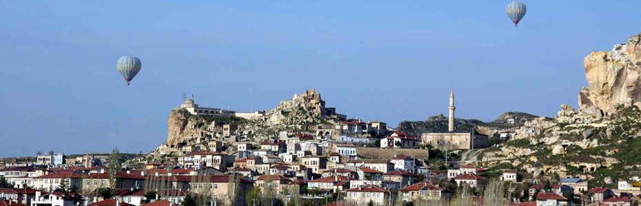
Urgup Cappadocia
One of the most important centers in Cappadocia is Ürgüp, 20km to the east of Nevsehir. Like Göreme, Ürgüp also had different names in history; Osiana (Assiana) in the Byzantine Period, Bashisar during the Seljuk Peroid, Burgut Castle in the Ottoman Period and Ürgüp as of the early years of the Republic.
The earliest known settlement in the area was on the skirts of Mount Avla, to the north of Damsa river called as “Tomissos” in the antiquety. Though, the most important remains belonging to the later period are the Roman tombs found in the towns and villages near Ürgüp. Also an important religious center during the Byzantine Period, Ürgüp was a bishopric of the rock-cut churches and monasteries found in the villages, towns and valleys cut churches and monastreies found in the villages, towns and valleys around Ürgüp.
In the 11th century, Ürgüp was an important citadel connecting with Nigde and Konya, important towns of Seljuks. The two buildings from this period are the Altikapili (Six Gates) and Temenni Tepesi (Wish Hill) tombs found in the town center. The 13th century Altikapili tomb, housing the remains of a mother and her two daughters, has six sides each with an arched window and no roof. Although researchers think that this is unlikely, one of the two tombs on the Temenni Hill is believed to belong to Seljuk Sultan Rüknettin Kiliçarslan Iv, built by Vecihi Pasha in 1268 and is known as “Kiliçarsalan Tomb” by the locals. The other one is believed to belong to Alaaddin Keykubat III.
Ürgüp became a part of the Ottoman empire in 1515. It was the first time in the 18th century when Damat Ibrahim Pasha, the Ottoman Grand Vezier, established the governorship in Nevsehir (Muskara). Ürgüp was then administered by the governorship making Ürgüp secondary in importance.
In his history and geography book “Kamus-ül Alam” written between 1888 and 1890, Semseddin Sami mentions 70 mosques, 5 churches and 11 libraries in Ürgüp.
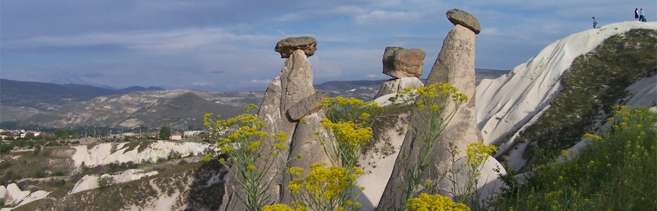
Fairy Chimneys
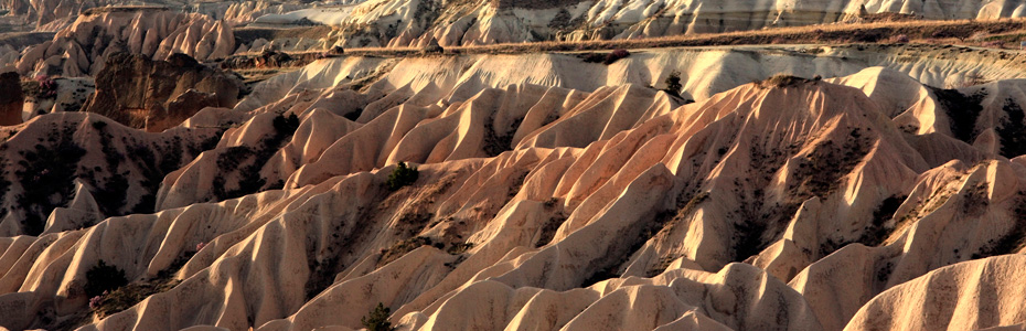
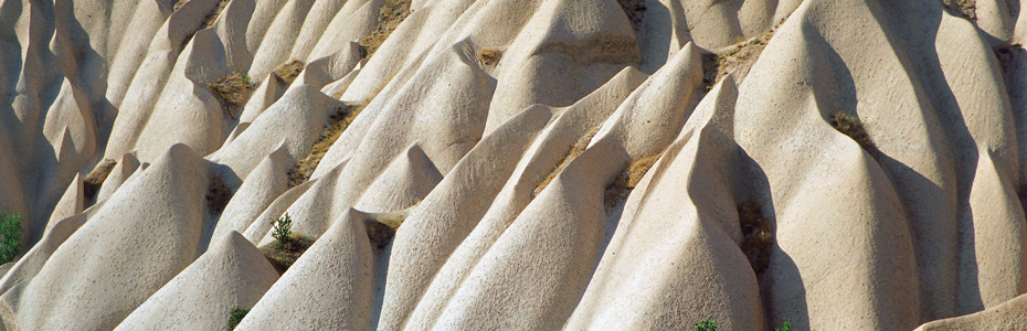
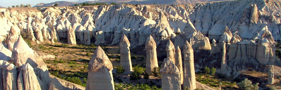
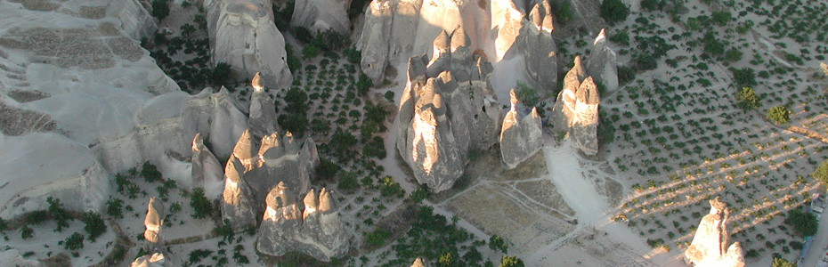
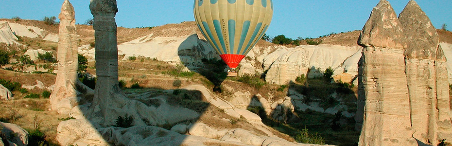
Fairy Chimneys in Cappadocia The interesting rock formations, known as “fairy chimneys”, have been formed as the result of the erosion of this tufa layer, sculpted by wind and flood water, running down on the slopes of the vallyes. Water has fonud its way through the valleys creating cracks and ruptures in the hard rock. The softer, easily erodable material underneath has been gradually swept away receding the slopes and in this way, conical formations protected with basalt caps have been created. The fairy chimneys with caps, mainly found in the vicinity of Ürgüp, have a conical shaped body and a boulder on top of it. The cone is constructed from tufa and volcanic ash, while the cap is of hard, more resistant rock such as lahar or ignimbrite. Various types of fairy chimneys, are found in Cappadocia. Among these are those with caps, cones, mushroom like forms, columns and pointed rocks.
Fairy chimneys are generally found in the valleys of the Uçhisar-Ürgüp-Avanos triangle, between Ürgüp and Sahinefendi, around the town of Çat in Nevsehir, in the Soganli valley in Kayseri, and in the village of Selime in Aksaray.
Another characteristic feature of the area are the sweeping curves and patterns on the sides of the valleys, formed by rainwater. These lines of sedimentation exposed by erosion display a range of hues. The array of color seen on some of the valleys is due to the difference in heat of the lava layers. Such patterns can be seen in Uçhisar, Çavusin/Güllüdere, Göreme/Meskendir, Ortahisar/Kizilçukur and Pancarlik valleys.
Goreme valleys
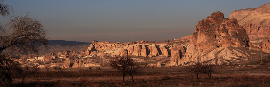
Göreme situated 10km from Nevsehir, is fonud in the area surrounded with valleys, within the Nevsehir-Ürgüp-Avanos triangle. The old names for Göreme are Korama, Matiana, Maccan and Avcilar. Since Göreme was referred as Korama in the earliest written document known from the 6th century, it is thought that that is the oldest name given to the place. In that document, it is said that St Hieron was born in Korama at the end of the 3rd century, was martyred in Melitene (modern Malatya) with his 30 friends and his hand was cut off and sent to his mother in Korama. A very big depiction of St.Hieron of Korama is found in the Tokali (Buckle) Church in Göreme Open Air Museum.
It is believed that Göreme and its surroundings were used as a necropolis by the people of Vanessa (Avanos) in the Roman Periods. Both the monumental twin pillared Roman tomb hollowed out into a fairy chimney in the centre of Göreme and the presence of numerous tombs in the vicinity support that idea.
Göreme an important Christian centre in the early years of the Middle Ages, was a bishopric administered by Mokissos near Aksaray in the 11th and 13th centuries. Despite the vast numer of monasteries, churches and chapels in the vicinity of Göreme, there are not many inscriptions bearing dates. For this reason, these religious buildings are mainly dated according to the iconography or architectural features.
Goreme Open Air Museum
By the end of the 2nd century a large Christian community had formed in Cappadocia. It is known that there were two bishoprics at that time; one in Kayseri, which, for a long time, continued to be a Christian center in the regon and the other in Malatya.
In the 3rd century, priests with good character changed theregion into a lively centre of Christian activity. In the 4th century Cappadocia became known as the land of the three saints; The Great St.Basil, Bishop of Kayseri; his brother St.Gregory of Nyssa, and St. George of Nazianus. These three men created a new unity in Christian thought, and many of St.Basil's thoughts and actions are still important dotay. An example of his doctrine is the advice to Christian with one piece of bread in a famine. He said that the Christians should give half of the bread to a fellow believer and trust in God to take care of him. St.Basil founded small, secluded settlements far away from villages and towns. Daily worship was carried out under the supervision of a preacher. These groups were not, however, priveleged gropus seperated from the community like similar communities in Egypt and Syria. St .Basil is important in that he introdued worship within the community in the churches of Cappadocia.
Goreme open Air Museum is the place where this kind of religious education was started. The same model was then introduced in Soganli, Ihlara and Açiksaray.
Karanlik Kilise, Dark Church
Karanlik (Dark) Church To the north, a winding stairway leads into the rectangular, barrel vaulted narthex of the Dark Church. This church has a cruciform plan, the arms of which are cross vaulted. There is a center dome, with four columns and three apses. This church gets its name from the tiny window in the narthex which only allows a small amount of light in. Due to the absence of light the colours of the frescoes are still vivid.
The church and the narthex are richly decorated in scenes from teh Bible and the story of Jesus. As in Elmali (Apple) and Çarikli churches there are also scenes from the old Testament. The church dates back to the end of the 12th and beginning of the 13th centuries.
Scenes : Deesis, Annunciation, Journey to Bethlehem, Tativity, Adoration of the Magi, Baptism, Raising of Lazarus, Transfiguration, Entry into Jerusalem, Last Supper, betrayal of Judas, Crucifixion, Anastasis, Women at the Tomb, Blessing and Mission of the Apostles, Ascension, Hospitality of Prophet abraham, Three Young Men in the Fiery Furnace and protraits of the saints.
Tokali (Buckle) Church
This is the oldest known rock-cut church in the region, and cmoprises of four sections: The Old Church with one nave; the New Church; the Lower Church under the Old Church; and the Parecclesion to the north of the New Church.
The single-naved, barrel-vaulted Old Church, built in the 10th century, today acts as the entrance to the New Church. Its apse collapsed when the New Church was added to the east wing. Frescoes are to be found on the vault and at the top of the walls. The life o Jesus is told on separate panels on the vault, running from left to right.
Uchisar Kalesi
Uçhisar is situated at the highest point in the region, on the Nevsehir-Göreme road, just 7km from Nevsehir. It is not known when Uçhisar was first inhabited, however, in style, it resembles Ortahisar and the Selime Kalesi (castle) in the Ihlara Region.
Uchisar CastleThe top of the citadel provides a magnificent panorama of the surronuding area. Many rooms hollowed out into the rock are connected to each other with stairs, tunnels and passages. At the entrances of the rooms, there are millstone doors, just like the ones in the underground settlements, used to control access to these places. Due to the erosion in places of this multi-leveled castle, it is unfortunately not possible to reach all the rooms. The fairy chimneys to the west, east and north of Uçhisar were hollowed out and used as graves during the Roman period. Inside these rock cut tombs, the entrances of which generally fac qest, are klines or stone slabs on which the bodies were laid. Many rock cut churches have been discovered not only on the skirts of the castle but also inside it. The reason for this may be the fact that Göreme, having numoreus churches and monasteries, is very close to Uçhisar. The simple Byzantine graves on top of the castle are not very interesting due to the fact that they have been eroded and ransacked. It is said that in towns with citadels, e.g. Uçhisar, Ortahisar and Ürgüp (Bashisar), long defence tunnels reached far into the surrounding areas. However, since the tunnels have collapsed in places, this theory cannot be confirmed, but is a popular myth as to the great distances they cover.
Beside toms, many dove-cotes were hollowed out into the castle, fairy chimneys around it and on the clifffaces. The local farmers, although they did not have much land,were in need of goods crops. Knowing that dove excrement could help them with this problem and increase the amount of crop they would get, farmers hollowed out dove-cotes into the sides of fairy chimneys and on the cliff gaces. Later the fertilizer was gathered and used in the fields.
Under Ground City in Cappadocia
Some of the most interesting cultural riches in the Cappadocia Region are the 150-200 known undergruond settlements of varying sizes. However, since there are cliff settlements of different sizes, in all the towns and villages in the region covering an area of 25 000 square km., this number maybe underestimated. Most of the rock settlements of this kind were built by hollowing out the tufa from the ground. Except the traces made by tools while hollowing, we do not have much information about the techniques they used.
The name “undergronud city” is widely used, however, only some of them were big enough to accommodate 30000 people and can be called “underground cities” but it is possible to call other small ones as “underground villages.”
Kaymakli Underground City
Even though the whole city has not been completely opened, and since only 4 floors have been uncovered, it is certain that Kaymakli is one of the largest underground settlements in the region. The number of the storage rooms in sucn a small area supports the idea that a great number of people resided here.
Kaymakli underground city is built under the hill known as the Citadel of Kaymakli, in the centre of the town 19km from Nevsehir, on the Nevsehir-Nigde road. It was opened to vsitors in 1964. In the village of Kaymakli, the ancient name of which was Enegup, the people have constructed their houses around nearly one hundred tunnels of the underground city. The inhabitants of the region still use the most convenient places in the tunnels as cellars, storage areas and stables, which they access through their courtyards. Kaymali Underground City is different from Derinkuyu Underground City in terms of both form and organization. The passages are low, narrow and sloping. Only 4 floors are open to the public, in which the spaces are organized around the ventilation shafts.
Derinkuyu Underground CityDerinkuyu Underground City
Derinkuyu is situated 29km from Nevsehir, on the road to Nigde. The city is approximately 85m deep. It contains all the usual rooms found in an underground city (stables, cellars, storage rooms, refectories, churhes, wineries etc.) Apart from these, a large room with a barrel vaulted ceiling on the second floor was a missionary school, the rooms to the left being study rooms.
From the 3rd and 4th floors onwards the descent is by way of vertical staircases which lead to a cruciform plan church on the lowest floor.
The 55m deep ventilatino shaft was also used as a well. Not every floorwas provided with the surface in order to protect the dwellers from poisoning during raids.
Derinkuyu Underground City was opened to visitors in 1965 but so far only 10% can be visited.
Mustafa Paşa, Sinasos
Mustafa Pasa (Sinasos) Mustafapasa 6km to the south of Ürgüp, was inhabited by Greek Orthodox families until the beginning of the 20th century. The houses dating back to the end of the 19th and beginning of the 20th centuries display fine examples of stonework. The Gömede valley, to the west of Mustafapasa, resembles a small version of the Ihlara valley. As at Ihlara, the walls of the valley house churches and shelters carved from the rock, and a river runs through the valley.
The important churches and monastreies around Mustafapasa are, the church of Aios Vasilos, the Church of Constantine-HNelene, churches in the Monastery Valley and, the Church of St.Basil in the Gömede valley.
There is also a caravanserai built during the Ottoman period and displaying fine examples of stone masonry and woodcraft.
Ortahisar Kalesi Castle Ortahisar
Ortahisar citadel, built both as a defence and as a settlement, is situated 6km from Ürgüp, on the road to Nevsehir. Typical examples of the raea's civilian architecture can be found among the houses skirting the citadel. The sides of the valleys are littered with carved out storage areas used for preserving local products such as apples and potatoes, as well as oranges and lemons brought from the Mediterranean.
Very interesting churches and monastreies can be fonud in the surrounding valleys. Among these are, Sarica Church, Cambazli Church, Tavsanli Church, Balkan Deresi Churches and Hallaç Dere Monastery.
Zelve Open Air Museum
The Zelve monastery complex is situated about 10 km out from Goreme on the road to Avanos . Although the churches here lack the elaborate frescoes of Goreme and other sites there's still plenty here to see. The series of valleys can provide you with a couple of hours walking, climbing and crawling about and in addition to the marked highlights (the Fish and Grape churches) there are innumerable rooms and passages to look at.
Zelve was inhabited until quite recently but you can almost see the place crumbling before your very eyes. There's probably an element of risk involved in exploring too enthusiastically but a guide should be able to balance the thrill of stumbling through pitch black tunnels by torchlight with an element of safety.
Avanos - Venessa
Avanos is the pottery centre of Cappadocia. The city is set on the banks of the Kizilirmak, meaning the Red River. The river gets its name from the clay that it deposits - the caly that is used for the pottery Avanos is famous for.
The main street of town has numerous shops and workshops selling plain and decorated pots and plates and you can watch the potters at work using kick wheels, the design of which has remained unchanged for generations. Many of the workshops will encourage you to have a go yourself. Groups of tourists are shipped in the whole time and there are always a few people willing to give it a go - always good for a few laughs.
Sights in town include the Caravanserai, a restored Han (travellers 'service station'), and the Ozkanak Underground city, a smaller version of those at Derinkuyu and Kaymakli.
Cavusin - Çavuşin
One of the oldest settlements in the area, Çavusin is sutiated 2km from Göreme, on the Göreme-Avanos road. The Church of St.John the Baptist offers a panoramic view of the village. This church and its paintigs date back to the 5th century, making the oldest church in the region. It had a large courtyard which is unusual for Cappadocia, this has been eroded away however.
Christian missionaries and communities once lived in the old Çausin valley, now in ruins. There are 5 churches at Gluludere, close to Çavusin. The Haçli Church (with the Cross), near the valley, was also used for defence against the Arab raiders.
Soganli Valley, Soğanlı Vadisi
This valley is situated near Yesilhisar in the province of Kayseri, 40 km southeast of Urgup, and 25 km to the east of Derinkuyu. Fractures and collapses during earthquakes hav added to erosion resulting in deep valleys and canyons. Soganli valley,which is divided into two has been occupied since the Roman period. The rock cones fonud on the sides of the valley were used a graves by the Romans, and later as churches by the Byzantines. The frescoes in the church date back to the 9th and 13 th centuries. Impartont churches in the valley are Karabas, Yilanli, Kubbeli and the Church of St.Barbara (Tahtali).
Ihlara Valley, Ihlara Vadisi
The Ihlara valley is number one in Cappadocia when it coems to spectacular scenery. It's removed a little from the rest of the Cappadocian sites it can be a little tricky to get to but it's worth a full day if you can spare one.
The gorge is 16 km long and both sides are lined with rock carved churches, about 100 in all. You can look at the more important of these in a couple of hours but it's very pleasant to spend an afternoon following the river down the valley and exploring on your own.
The climb down to and especially up from the gorge can be demanding and probably shouldn't be attempted if you're feeling frail. To make the most of your time here a full day and a picnic is a good idea and will repay the effort in terms of a relaxed days pottering about admiring the churches and the valley's beautiful scenery.
Guzelyurt, Güzelyurt Aksaray
Guzelyurt is 45 km from Aksaray and 15 km from Ihlara. With its beautiful nature and 19th century architecture it is an important place for visitors to Cappadocia.
Gregory of Nazianzus, who worked hard to spread Christianity in the area, turned Guzelyurt into an important center.
Churches found in guzelyurt are, Yuksek, Kizil, Silvisli, Ahmatli and Koc. Guzelyurt also boasts a church built in 1891, now used as a mosque.
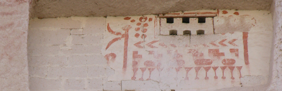
Cappadocian Dove-Cotes
Doves are the symbol of peace and devotion to family in Islan whereas regarded as a symbol of the “Holy Spirit” in Christianity.
Dove-cotes, hollowed out into the upper parts of almost all the valleys and fairy chimneys, generally face east or south sides of the valleys. Since doves are in need of water to digest the grains they hava already stocked in their craws, they are also named “the guarding birds of the fountains”. For this reason dove-cotes were hollowed out near the water sources. Although most of the dove-cotes in the region of Cappodocia date back to the end of the 19th and the beginning of the 20th centuries, there are few examples dating to the 18th century. These small buildings do not attract our attention much but are important in terms of showing us Islamic painting art which is rarely fonud in Cappadocia region.
The reason behind hollowing out dowe-cotes was not to catch and eat pigeons but to use their excrement as fertilizer. The locla farmers used pigeon droppings as fertilizers for generations, and for this reason, a great number of dovecotes were hollowed out.
Caravanserai
were built along roads running from Antalya-Konya-Kayseri to the land of Turkomans passing through Erzurum and Tabriz and from the Black Sea region to Irak via Amasya-Tokat-Sivas-Malatya-Diyarbakir at a distance of 30-0 km, one day camel trek.
It is possible to see some of the most beautiful examples of caravanserais in the region of Cappadocia, especially between Aksaray and Kayseri, since it is an intersection, east to west and sout to north.
Sarihan Caravanserai
It is located in the valley of Damsa, 5km southeast of the town of Avanos in the vicinity of Nevsehir and 6km east of Urgup. The han is on the Aksaray-Kayseri route in the East-West connection.
Sarihan, build during the reign of Izzettin Keykavus 1-upon his orders- in 1249, covers an area of 2000 m square.
Sarıhan KervansarayıYellow, reddish pink and light brown regular sotne blocks were used as building material in Sarihan. A decorative look was achieved by using stone of two different colors in the arches of both the monumental portal and the inner portal.
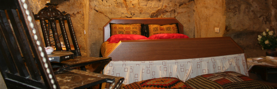
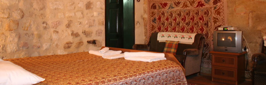
Cappadocian Civil Architecture, Kapadokya Evleri
19th century Cappadocian houses were built on hill sides, either carved out of the rock or built from large cut stones. Volcanic stone is the only architectural material in the region, used for building as it is soft when extracted and can therefore easily be cut and shaped. It hardens on contact with air to form a very resistant material. The abundance of stone in the area, and the ease of use have created a buliding technique unique to the area.
Wood is used for courtyard gates and the houses'doors. Rosette and ivypattens are used as decorations above the arched doors.
The areas between floors are decorated in up to three rows of rosettes, fans, stars, palmet, weather vanes and stylised plant patterns.
Windows are grouped in twos and threes and stylised plant patterns are also used as decorative borders. Two types of window are used, either two panes opening separately or guillotine style.
In both types of house there are numerous living rooms, a kitchen,c ellar, store room, an oven (tandir), wine vat etc. Niches found in the guest rooms are decorated with paintings of vases full of flowers under silk, tasseled curtains, scenes from nature or women filling, or carrying water vessels. These scenes ara painted on plaster.
The most interesting examples of local architecture belong to the end of the 19th and begining of the 20th centuries. Examples can be fonud all over the region, but partiularly in urgup, Ortahisar, Mustafapasa, Uchisar, Goreme, Avanos, in Guzeloz and nearby Baskoy in the province of Kayseri and Guzelyurt near the region of Ihlara.
|